image

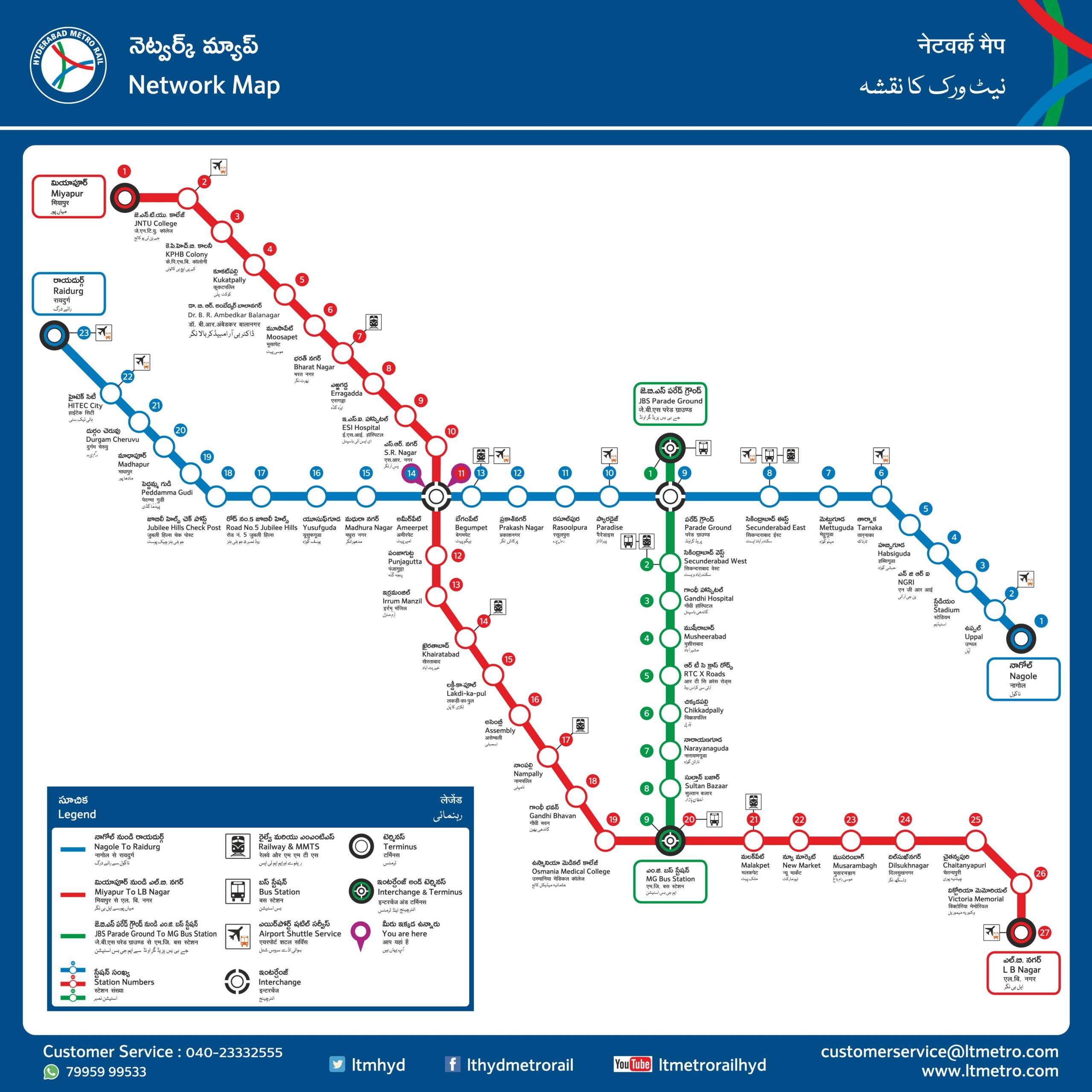
Hyderabad Metro Map

If you’re planning to travel in Hyderabad, one of the fastest and most efficient ways to get around is by using the Hyderabad Metro. And the best way to navigate the city’s metro system is by using the Hyderabad Metro Map. This map is designed to provide you with all the information you need to make your journey as easy and hassle-free as possible.

The Hyderabad Metro Map features a detailed layout of all the metro lines and stations, so you can quickly and easily plan your route to any destination within the city. Each station on the map is clearly marked with its name, so you can easily identify it while traveling.

Whether you’re a local resident or a first-time visitor to Hyderabad, the Hyderabad Metro Map is an invaluable resource that can help you navigate the city’s metro system with ease. So why wait? Bookmark this Hyderabad Metro Map page now and start exploring the vibrant and beautiful city of Hyderabad!

“Hyderabad Metro Rail is operational from 06:00 am to 11:00 pm. The first train starts at 06:00 am and last train departs at 11:00 pm from all terminal stations”

Hyderabad Metro Map

Hyderabad Metro Map - Stations of Red Line Corridor-1

1. L.B.Nagar (Terminal)
2. Victoria Memorial
3. Chaitanya Puri
4. Dilsikhnagar
5. Musarambagh
6. New Market
7. Malakpet
8. M.G.Bus Station (Interchange for Corridor-2/Paradise- Falaknuma)
9. Osmania College
10. Gandhi Bhavan
11. Nampally
12. Assembly
13. Lakdi – ka -Pul
14. Khairtabad
15. Irrum Manzil
16. Punjagutta
17. Ameerpet (Interchange for Corridor- 3/ Nagole – Raidurg)
18. S.R.Nagar
19. ESI Hospital
20. Erragadda
21. Bharat Nagar
22. Moosapet
23. Balanagar
24. Kukatpally
25.KPHB Colony
26. JNTUCollege
27. Miyapur (Terminal)

Hyderabad Metro Map - Stations of Green Line - Corridor 2

1. Falaknuma (Terminal)
2. Shamsheer Gunj
3. Shalibanda
4. Charminar
5. Salarjung Museum
6. M.G.Bus Station(Interchange for Corridor- 1 / Miyapur- L.B.nagar)
7. Sultan Bazar
8. Narayanguda
9. Chikkadapally
10. RTC X Roads
11. Musheerabad
12. Gandhi Hospital
13. Secunderabad West
14. Parade Ground (Terminal)

Hyderabad Metro Map - Stations of Blue Line - Corridor 3

1. Nagole(Terminal)
2. Uppal
3. Stadium
4. NGRI
5. Habsiguda
6. Tarnaka
7. Mettuguda
8. Sec’bad (East)
9. Parade Grounds (Interchange for Corridor-2 / Parade Grounds – Falaknuma)
10. Paradise
11. Rasoolpura
12. Prakash Nagar
13. Begumpet
14. Ameerpet (Interchange for Corridor-1 / Miyapur-L.B.Nagar)
15. Madhura Nagar
16. Yousufguda
17. Road # 5 – Jubilee Hills
18. Jubilee Hills Check post
19. Peddamma Temple
20. Madhapur
21. Durgam Cheruvu
22. Hi tech city
23. Cyber Gateway
24. Rai Durg (Terminal)

The Hyderabad Metro Rail has expanded its services throughout the city by linking three separate lines via three interchange stations.

  • Red Line – Miyapur to L B Nagar via MG Bus Station, Nampally & Ameerpet
  • Green Line – JBS Parade Ground to MG Bus Station via Secunderabad
  • Blue Line – Nagole to Raidurg via Secunderabad & Ameerpet

Interchange stations connecting two different lines

  • MG Bus Station connects Red Line and Green Line
  • JBS Parade Ground connects Green Line and Blue Line
  • Ameerpet Station connects Red Line and Blue Line